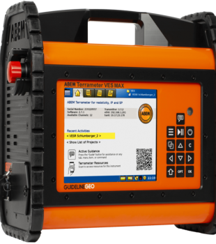


ABEM Terrameter LS2
The ABEM Terrameter LS 2 is an advanced resistivity and IP solution equipped with flexible, user-friendly, and innovative features. It offers an ideal usage for geotechnical, groundwater, mineral, environmental surveys, and academic research.It provides high efficiency across a wide range of applications, from repetitive and autonomous monitoring studies performed on electrode arrays hundreds of meters long to precise measurements made with centimeter-spaced electrodes in laboratory environments. Thanks to its versatile system structure, it can be used effectively in both routine field applications and advanced research projects.
Product Brochure
- Flexible and user-friendly system structure
- Resistivity and Induced Polarization (IP) measurement capability
- Suitable for geotechnical, groundwater, mineral, environmental surveys, and academic research
- System suitable for working with electrode arrays hundreds of meters long
- Suitable for repetitive and autonomous monitoring applications
- Precision measurement capability with centimeter-spaced electrodes in laboratory environments
- Versatile architecture adapting to different field conditions
- High efficiency for routine field applications and advanced research projects
- Self Potential (SP) measurement option
- Borehole resistivity logging support with SAS Log accessory
Application Areas
Groundwater Research
- Detection of groundwater presence
- Differentiation of fresh, brackish, and saline water zones
- Monitoring of drawdown and recharge processes in aquifers
- Estimation of aquifer distribution and boundaries
- Strengthening the differentiation of clay and water units with IP data
- Refining hydrogeological models with SAS Log
Geological and Geotechnical Mapping
- Use in engineering geology and infrastructure projects
- Determination of bedrock depth and assessment of strength
- Mapping of contamination plumes
- Seepage monitoring in dams and embankments
- Investigation of potential slip planes
- Mapping of voids and locating deep, large infrastructure elements
Mineral Exploration
- Effective use in near-surface mineral exploration
- Rapid recording of resistivity and IP data
- Enhancing research capacity with SP measurement
- Evaluation of ore types via resistivity and IP responses
- Contribution to creating a more holistic subsurface model
- Reliable data collection in near-surface mineral prospection studies