


Geoexplorer
GeoExplorer is a comprehensive software suite developed for geophysical data processing aimed at ground characterization. It consists of modules for collecting, processing, analyzing, and interpreting various field data. Thanks to this structure developed for MASW, HVSR, refraction, downhole, vibration analysis, and other specialized geophysical applications, users can efficiently evaluate different data types within a single software ecosystem.
Product Brochure
- Geophysical data processing software suite developed for ground characterization
- Modular structure supporting data collection, processing, analysis, and interpretation processes
- Specially developed software modules for different geophysical methods
- Integrated framework combining field studies with office analysis processes
Software Modules
GeoExplorer DoReMi: A module developed for data collection with the DoReMi seismograph. It is suitable for data recording and field use. Necessary drivers must be installed prior to setup.
GeoExplorer MASW: MASW data processing module developed for Rayleigh and Love waves. It allows quality control via refraction data and supports the comparison of different shots.
GeoExplorer SSV: A module developed for the investigation of potential water reservoirs. It operates based on the search for specific seismic facies and utilizes a near-vertical reflection approach.
SEISMOWIN LOG-MT: A module developed for HVSR data collection with GeoBox or VelBox. It offers free usage.
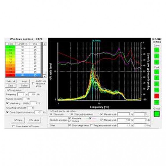
GeoExplorer HVSR: A module providing the processing of data recorded by GeoBox, VelBox, or other seismographs using the HVSR method. Data evaluation can be performed using the Nakamura method.
GeoExplorer REFRACT: A comprehensive toolkit developed for ground investigations using refraction data. It supports tomography, intercept, and GRM methods; it also includes a wide range of signal processing tools.
GeoExplorer DOWNHOLE: A downhole data processing module currently under development. The data collection component is implemented in the DoReMi software. It supports the processing of data from the SS-DH-5C sensor or third-party sensors and seismographs.
GeoExplorer VIBER: A vibration analysis module developed for assessing damage and disturbance effects in civil and industrial structures. It operates in compliance with UNI 9916 and UNI 9614 standards.
GeoExplorer MARW: Currently under development, this module works integrated with the DoReMi software. It enables data recording, field quality control, and analysis to generate 1D models.

